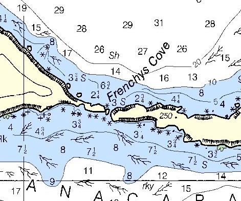
Chart18729Anacapa PassageGoogle Map
| Loc: North Shore Anacapa Island | Lat: N34-00.5 | Long: W119-24.4 | Last visit:July 2021 |
| Tide/Sun/Moon/WX | Dist: 11 | Port Hueneme | WX |
| Skipper: Capt. Dan | Boat: S/V Sancerre | Capt. Dan | Port: Channel Islands Harbor |
| Landing | Restrictions | NPS Alerts | Local Notice to Mariners |
Let’s Do Lunch at Frenchys
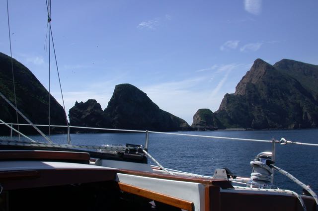
Frenchys Cove, the most popular spot on the island, provides some protection from west wind and swell. We usually anchor in about 25′ – 35′ of water slightly west of the gap between the west island and the middle island. But there are numerous spots sheltered (somewhat) from the west wind. When the wind tends to the north, the areas of shelter are reduced. Any wind of significance from NE to NW will make this spot uncomfortable and possibly dangerous. This is decidedly not a suitable overnight anchorage. If the wind is out of the south, you’re well protected from wind and swell along the entire north coast.
Restrictions and Cautions
A permit is not required to land or hike on East Anacapa Island or at Frenchys Cove. West Anacapa Island (except at Frenchys Cove) is a protected research natural area and is closed to visitor access. The waters on the north side of West Anacapa Island are closed most of the year to protect nesting pelicans as well.
Note: PWC – personal watercraft – are prohibited in Marine Reserve Areas. Click for Marine Reserve information and restrictions.
Cautions
– Getting to any of the Channel Islands means crossing the Traffic Separation Zone i.e. “Shipping Lanes.” The rules tell us sailors to remain clear, but, if we must cross to do that at best possible speed at right angles to the zone.
Coastwise traffic is frequently heavy and the massive container ships often truck through at 18 knots. If equipped with radar, it is wise to keep a close watch even on clear days. Monitor #16 and turn up the radio volume in case one of these monsters hails you, and, of course, keep a sharp visual watch. If you’ve got AIS, well, good for you, but you still have to maintain a sharp lookout, especially on clear days when high speed sport fishers race back and forth with little regard for other traffic.
Approach
When heading to Frenchys from Ventura or Channel Islands Harbor, shape course for the mountain on the West Island.
We anchor in 20-25 feet of water, which puts us pretty close to shore. For a longer (longer than lunch) stay, I drop the hook in 30 -35 feet to get a bit more margin from the rocks.
Approaching Anacapa from the West, specifically, when leaving Smuggler’s anchorage on Santa Cruz, the West Island is prominent. A reef extends a bit to the west. According to the Coast Pilot, approaching in low visibility can be dangerous as the slope of the beach is precipitous and soundings give no warning of the proximity of the island.
The Anacapa Light, Arch Rock and Cathedral Cove, all great photo ops, lie about 2.5 nm east.
For additional NPS information on Anacapa wonders, history and culture – including info about Frenchy LeDreau and his cove; click NPS Anacapa Info
Who was Frenchy?
Described as a hermit who liked people, Raymond LeDreau arrived on Anacapa in 1928, or thereabouts. and stayed in the vicinity for nearly three decades. Learn more at Frenchy LeDreau.
Updates
If you have new or amplifying information concerning this anchorage or the surrounding area, please contact Capt. Dan. His e-mail link and phone are top left.


 on your first leg.")