| Loc: north coast Santa Rosa | Lat: N34-58.4 | Long: W119-58.64 | Last visit: Sept 19 |
| Tide/Sun/Moon/WX | Dist: 9 | Bechers Bay | WX |
| Chart | 18728 | Santa Cruz Channel | NPS Alerts |
| Skipper: Capt. Dan | Boat: S/V Sancerre | Capt. Dan | Port: Channel Islands |
| Landing Permit | Not Required | ||
| Local Notice to Mariners |
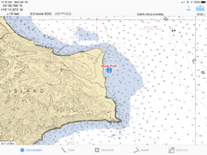
Skunk Point Anchorage
We’ve only spent one night here and that one was in very settled weather. The island protects from swells out of the west, but there is scant protection from the wind behind the 300′ hill. We anchored not long before sunset setting our hook in 30′ of water over a sand bottom. We rigged our riding sail and settled in. During the night we were twisted and turned by tidal flow, which ran north and then south a few hours later. There was a bit of uncomfortable chop as a result of conflicting currents, but that did not cost us much sleep.
If you’re planning on surfing, this is a great spot. If you’re just looking for a settled place to drop your hook, NW Bechers Bay is a better bet.
Hazards
 There are no uncharted hazards and the rocks that create the break are quite obvious.
Approach
Nothing tricky here. It’s wide open and you can safely anchor into about 25 feet, probably even closer, but we always prefer a little sea room in case of wind shifts.
Going Ashore
The area is home to snowy plover nests and access is restricted much of the year.
“March 1 to September 15: Skunk Point to East Point Back Beaches and Sand Dunes Closed
The back beaches and sand dunes between and including Skunk Point and just north of East Point are closed to hiking from March 1st to September 15th to protect the nesting area for the snowy plover, a federally listed, threatened shorebird. Please remain on the wet sand (below mean high tide) or the road throughout this area.”
Consult the National Park Service web pages for all closures and other restrictions.
